Geoinformation system for water cadastre

Геоінформаційна система для водного кадастру

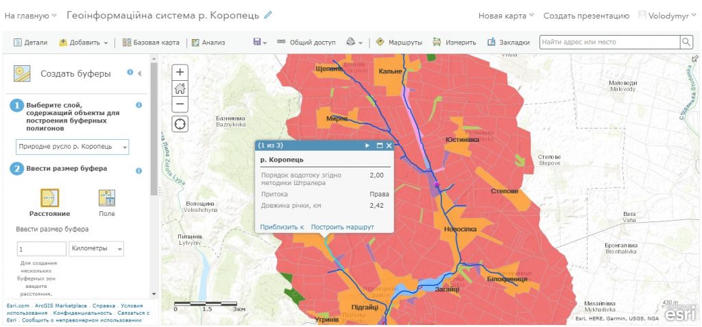
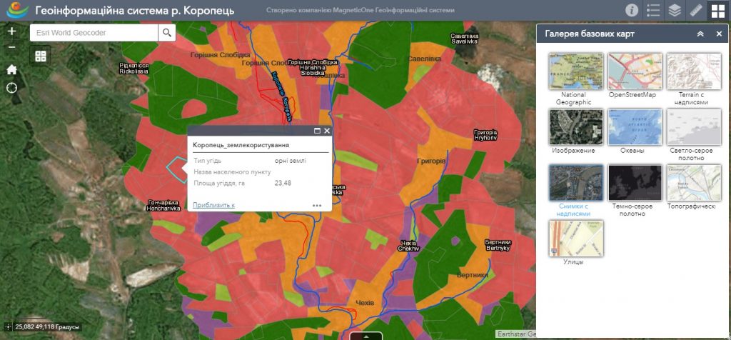
The main assignment of the GIS for water cadastre is the ability to collect data, create databases, enter them into computer systems, store, process, convert, and then issue them at the user’s request. The opportunity of convenient for the end user analyzing of information in a cartographic form or in the form of tables, graphs, diagrams. The decision support system for managing water bodies is based on modern advances in geoinformation technologies and web cartography. The implementation of the GIS for the water cadastre allows to facilitate and automate the work, significantly expand the use of topographic and thematic maps that contain a large amount of information necessary for the analysis of the hydrological regime of water bodies.

Solve issues of effective water resources management by using cartographic and aerospace information, get quantitative and qualitative information about water bodies, which are inaccessible during field studies or measurements. Get online access to data using a mobile mapping app synchronized with the geoinformation system.

New water management opportunities

  • create and maintain up to date register of water and water management facilities with relevant reference information (technical characteristics, documentation, etc.);
  • carry out operational monitoring of the surface waters quality (make changes and promptly display data on special water use, water quality, level of pollution, etc.);
  • create and present web maps of water facilities, thematic maps for areas of activity depending on the needs of individual departments and specialists;
  • carry out operational management in emergency situations (floods, overflows), simulate and predict flooded areas and etc;
  • ensure collection of data on violations in the use of water resources and adjacent territories (within the water and coastal protection zones) under field conditions in real time using a mobile app synchronized with the geoinformation system;
  • ensure the protection of water resources and present planned measures to regulate and improve the state of river systems.
Геоінформаційна система для водного кадастру

The database structure of GIS for water cadastre

  • basic geoinformation resources (cartographic basis): digital topographic foundation, digital orthophotoplans, digital elevation model, registry of geographical names;
  • thematic information resources: a network of water bodies (rivers, lakes, canals, reservoirs, etc.), water sampling sites, localization of hydraulic structures, and etc;
  • complex or problem-oriented information resources, which are a set of basic and thematic resources, combined into a certain system with the formation of a new resource to solve a specific problem of territory management, for example, a limited development area within the boundaries of water protection zones, a flooded area, etc.

Services which will be provided prior to solution

  • Consulting
  • Scanning of paper documents and maps
  • Georeferencing of cartographic materials
  • Digitization
  • Provisioning of interactive map database
Коротка інформація

[contact-form-7 id=”10714″ title=”Форма партнерства”]


×
This site is registered on wpml.org as a development site.