Geoinformation system for emergency solutions

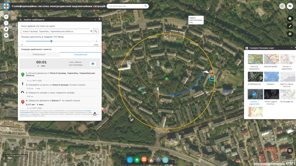
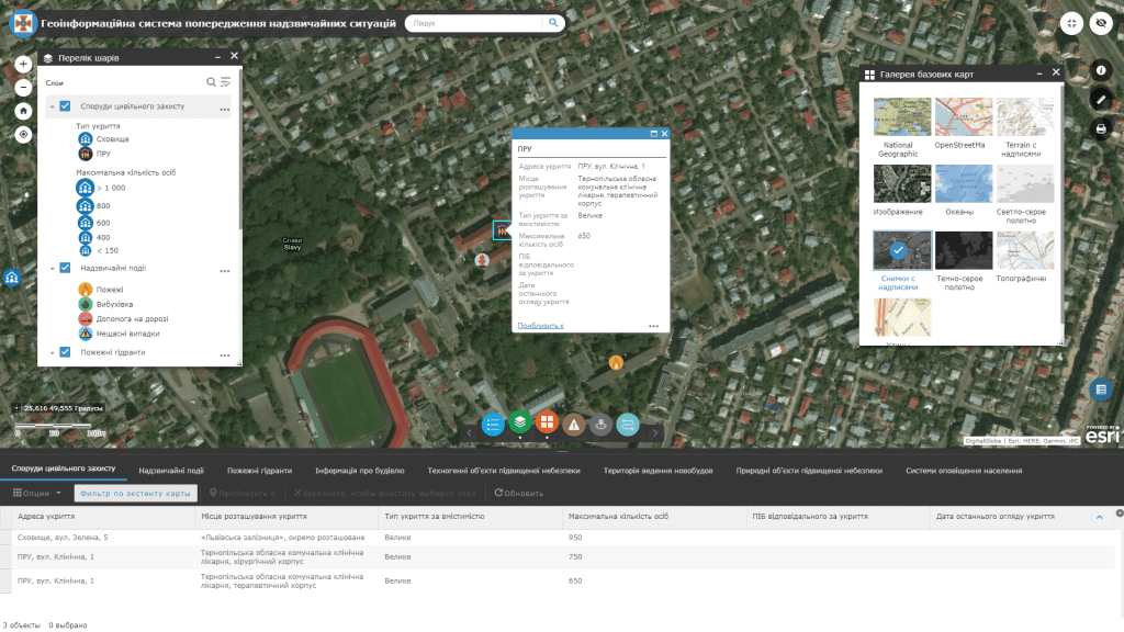
The era of applying the geoinformation systems to emergency solutions is relevant both for state and local government bodies and for the general public. The state of protection of the population, objects of the economy and the environment from various kinds of emergency situations largely depends on the measures developed in advance to prevent and eliminate emergency situations of a natural and man-made nature.

Predict the likely dangers in emergency situations, reduce the negative consequences for people, the economy and the environment. Implement state-of-the-art technology solutions and get an innovative civil protection strategy where the focus is on early warning of emergency situations and instant response based on monitoring and display of spatial data.

Геоінформаційна система для рішень у надзвичайних ситуаціях

GIS on the guard of civilian security

Use modern methods of integration of geoinformation, space and Internet technologies to obtain objective, timely and adequate information about potentially dangerous situations. Solve a complex of tasks for the prevention and elimination of emergency situations with the geoinformation information system:

  • create banks of digital spatial information about areas experiencing major natural and man-made impacts (earthquakes, floods, fires, etc.) and those parts of the terrain where facilities are dangerous in terms of emergencies (dams, gas and oil storage facilities, chemical enterprises, etс.);
  • get real-time spatial information about emergency situations (answer to the question of what happened and where?);
  • determine the shortest routes for the emergency services and emergency response forces;
  • quickly build evacuation routes from emergency areas to safe places, including civil defense storage, various shelters, and the like;
  • determine the required number of forces and means, as well as develop a strategy and tactics to assist;
  • show the inconsistency of the state of equipment and tools that directly affect the safety of the population (for example, confirmation of compliance with the safety of buildings, structures, fire safety requirements, the condition of fire hydrants) using the audit subsystem synchronized with GIS;
  • predict the development of emergency situations in order to prevent or reduce the negative impact on the population, territory and environment.

The structure of the GIS database for emergency solutions

  • basic geoinformation information resources or cartographic basis: the only digital topographic and geodetic basis of the city, digital orthophotoplans, the system of buildings and structures, the register of geographical names, and the like;
  • thematic information resources are supplemented with an appropriate attribute component: law enforcement points, medical facilities, civil defense stores, shelters, and epicenters of natural disasters are presented as thematic layers of the geoinformation system;
  • complex or problem-oriented information resources, which are a combination of basic and thematic resources, are combined into a certain system with the formation of a new resource for solving a certain problematic task of managing the territory, for example, a zone of emitting highly toxic substances into the atmosphere in a gaseous state, a flooded area in depending on the height of rising water levels in nearby rivers and others.
Геоінформаційна система для рішень у надзвичайних ситуаціях

Services which will be provided prior to solution

  • Consulting
  • Scanning of paper documents and maps
  • Georeferencing of cartographic materials
  • Digitization
  • Provisioning of interactive map database
Коротка інформація

[contact-form-7 id=”10714″ title=”Форма партнерства”]


×
This site is registered on wpml.org as a development site.