Geoinformation modeling

Геоінформаційна система

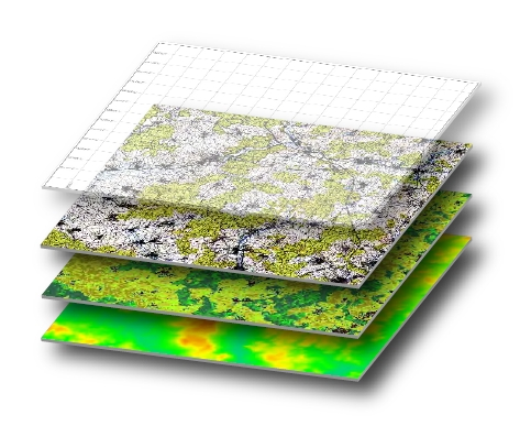
Geoinformation modeling – is a high-tech process of creating a terrain model of certain territory in the environment of geographic information systems. The created model visualizes the quantitative and qualitative parameters of the simulated area, presents the intensity of the processes (for example, geomorphological, hydrological, technological), gives an objective assessment of the state of the object (urban environment, individual components of the natural environment, human economic activity). Typically, GIS modeling is a decision-making tool in the development of recommendations for optimizing environmental management, urban planning, reducing the destructive anthropogenic environmental impacts, preventing the occurrence of man-made incidents and the development of dangerous phenomena and processes.

Get the opportunity to understand complex structures, manifest and justify spatial processes and patterns that are important for your business, using data from cartography and GIS modeling. Use geoinformation modeling to display spatial data, visualize information and knowledge.

Goal and tasks of geoinformation modeling

One of the main strategic goals of geoinformation modeling is to “see the whole”. Thanks to geoinformation modeling provided that a large amount of reliable and accurate data is introduced into the system, the user can detect deep system interconnections and trends that are not available using traditional cognitive methods. Thus, for example, a digital terrain model developed on the basis of GIS modeling serves as a reliable foundation for decision-making regarding the future state of the territory.

Another strategic goal of GIS modeling is to “manage location”. In this case, geoinformation modeling can provide a number of important analytical capabilities:

  • object location analysis;
  • building density models of phenomena;
  • search for objects within a specific area;
  • nearest neighborhood analysis;
  • changes modeling;
  • definition of spatial attributes of objects;
  • distribution of objects into categories;
  • search and definition of distribution patterns of spatial and attribute data;
  • 3D visualization of the final results.

Work examples

One of the most labor-intensive options for geoinformation modeling is the creation of a digital elevation model (DEM). The finished digital model is capable of solving a wide variety of tasks:

  • calculation of morphometric indicators – slope angles and slope exposures;
  • evaluation of the shape of the slopes through the curvature of their transverse and longitudinal sections;
  • building cross-sectional profiles of the relief;
  • analytical “washing” of the relief;
  • 3D visualization of the relief in the form of block diagrams;
  • building contours by a set of elevation levels;
  • orthotransformation of aerial photographs and satellite images.

Of particular interest are such developments for public authorities, representatives of industry (rural, forest, water), public services (water utilities, heating systems), etc.


Коротка інформація

[contact-form-7 id=”10714″ title=”Форма партнерства”]


×
This site is registered on wpml.org as a development site.